
As expected, summer is gradually coming back, and it will become hotter at times too.
Thanks to Andy for the photograph.
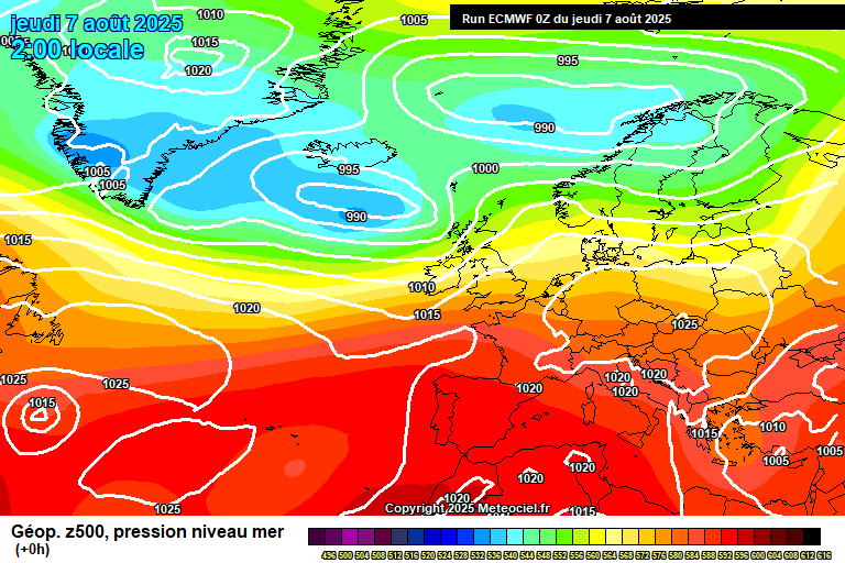
So the general picture still sees us in a westerly flow, low pressure to the north, high pressure over much of Europe. Considering that this is, on average, when maximum temperatures peak, much of Europe isn’t that hot right now – 33’C in Athens, for example. The European heatwave of June and early July has certainly subsided.
It’s a bright though fairly cloudy start to Thursday, we have a weak weather front slowly crossing today, which will bring generally thicker cloud for the afternoon and maybe a little light rain later in the day. Probably getting to 22’C or just under, becoming breezy too. Cloud thinning overnight, down to around 12’C.
Friday sees a lot of high cloud around making the sunshine hazy, and some fair-weather cloud – though generally the trend will be towards something sunnier as the day goes on. Warm, 25’C is achievable. Mostly clear skies overnight, down to around 11’C.
Saturday sees good spells of sunshine. Some fair-weather cloud bubbling up, notably during the lunchtime period. Very warm, reaching around 26’C. Mostly clear skies overnight, down to around 11’C.
High pressure remains in control for Sunday, long spells of sunshine, some fair-weather cloud, and very warm – around 26’C, maybe a tad more. Mostly clear skies overnight, down to around 13’C.
For the start of next week, we start to pick up more of a continental flow, so it should become hotter.

Some of the details becoming more uncertain for Monday, though broadly speaking a sunny day, though perhaps the sunshine hazier than it has been. A very small, say 5% chance, of a heavy shower developing for late afternoon/evening, and some uncertainty on temperatures. Hotter, for sure, but anywhere in the range of 28’C to 32’C, depending on exact direction of the breeze. A much warmer night than we’ve had for a few weeks, around 18’C.
More likely, it will remain broadly hot and sunny for Tuesday, though not especially high confidence. So good spells of sunshine, and temperatures somewhere between 27’C and 31’C.
That’s as far as I can go with any confidence on details.
There’s a reasonable chance that the hot and sunny-ish weather can hang on a few more days, but likewise we might return to something more westerly like we have now (warm and mixed weather), and a small chance instead of a more thundery low developing. Quite a few options for the second half of next week and into next weekend – maybe we’ll go through all of them!
Generally speaking for the next 2-3 weeks, it should be hotter, sunnier and drier than normal – but there will be some cloudier days in the mix, heavy/thundery showers possible on some days.
Have a very pleasant weekend, I shall be ensuring I get some sunshine at some point – next forecast will be on Sunday morning.
Any comments?
No comments yet. Be the first to comment!