
From unusually mild, to unusually wet – then to unusually cold. Lots going on this week!
Thanks to Tara for the photograph.
The general picture sees the low pressure which has been stuck to the west of us being pushed down towards Spain/Portugal where it will cause flooding issues in places – and notably high pressure developing towards Greenland/Iceland which will allow colder air to sink south in a couple of days time.
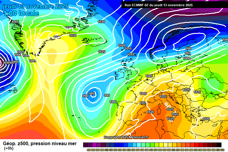
Much of Thursday will be reasonably pleasant and very mild, quite a lot of high cloud and some lower level cloud, but there will be reasonable amounts of hazy sunshine – and it will reach 16’C, perhaps even 17’C – quite something for the time of year. By late afternoon rain will start to develop, showery at first but becoming persistent through early evening and heavy. By late evening it will have pushed north of us, but then further rain will develop overnight. A mild night and becoming breezy, around 12’C.
Friday sees the weather front stall across England – at the moment the focus of the heaviest rain looks like it will be through the Midlands, and enough rain will fall (a month’s worth or more, in places) to cause flooding in places prone to flooding in large rain events. Probably we escape the worst, but this isn’t set in stone. So the more likely outcome is outbreaks of heavy rain, occasionally very heavy – though some drier spells too. Later in the afternoon/early evening there is the potential for some very heavy and possibly thundery showers mixed in. Breezy and just about hanging onto the mild weather, around 13’C. Any remaining rain will gradually ease in the evening, remaining cloudy overnight – around 10’C.
Saturday looks mostly cloudy but mostly dry – some bits of light rain/drizzle still possible. Perhaps a little sunshine at times later in the day. Still mild, 13’C and breezy. Remaining cloudy overnight with bits of light rain/drizzle at times, and around 10’C.
By Sunday the wind turns more north-easterly, so a colder flow starts to make its way down here. Still lots of cloud around, some bits of light rain/drizzle at times in the morning – some brighter spells in the afternoon. Around 10’C but feeling colder than it has…because it has been so unusually mild. Some clear spells developing overnight and a chilly night, down to around 3’C – and a chilly wind too.
For Monday we’ll be in a northerly flow.
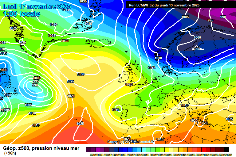
So a colder feel at around 9’C, but plenty of sunshine – and some bits of cloud at times. Feeling chilly in the northerly breeze. A colder night, potentially getting down to around 0’C – so frost possible, though some uncertainty on whether there will be enough clear spells.
Tuesday looks broadly a mixture of cloudy spells and sunny spells, a chance of a stray shower and around 8’C. A fairly cold night likely, down to around 1’C – some showers possible, more likely of rain but not impossible that they could be a wintry mix.
Wednesday looks colder as the northerly digs in. Some uncertainty on details, more likely good spells of sunshine, but there is a chance of something cloudier with showers, and a small chance they could be wintry. Around 5’C but feeling colder in the northerly wind. A cold night – potentially below 0’C though it depends on sufficient clear skies, and that is uncertain at this stage.
Thursday will remain on the cold side. More likely dry with good spells of sunshine, but a small chance of some showers – and a small chance of those having a wintry nature. Around 5’C. A frost probable overnight with a good chance of sub-zero temperatures.
Probably still on the cold side for Friday, uncertain on weather conditions.
A trend to milder conditions after that is probable – when milder air (with rain) arrives is uncertain, maybe Saturday but more likely Sunday/Monday.
So the latter part of November probably mild with wind/rain at times, and perhaps early December too.
There probably are greater chances of cold spells than previous winters if you go on background signals, but also we are experiencing a warming climate and changing pressure patterns – high pressure over Spain/Portugal does seem to have become more established than normal in recent winters (not sure if this is climate change or just a longer-term trend that will alter at some point), and this tends to stop cold air getting here.
Of course, this coming cold spell is happening when low pressure is over Spain/Portugal. It will be an interesting winter from a forecasting perspective anyway.
At this stage maybe January is the more likely month for cold spells, though there are signs that the latter half of December could feature some colder than normal weather too.
Do keep an eye on the Met Office forecast for Friday if you have plans, especially if you are going to/through the Midlands as there will likely be flooding in places.
Any comments?
No comments yet. Be the first to comment!