
Well it’s autumn, and theres a fair amount of wind, rain and showers to contend with this week.
Thanks to Tara for the photograph.
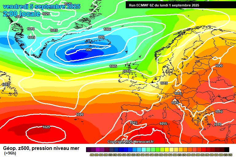
The general theme to start the week sees low pressure in charge, centred close to the west of Scotland – and it will stay roughly in that area as it spins around for a few days.

Monday starts sunny but showers will quickly develop and spread inland, heavy, perhaps very heavy with a small chance of thunder, most places catching a fair few showers during the course of the day – you’d be very lucky if it stays dry in your area. Reaching around 20’C and breezy, especially in showers. Mostly clear skies overnight, though a stray shower possible, down to around 11’C.
Tuesday starts bright/sunny but cloud will quickly arrive with an organised cluster of heavy showers/showery rain. Potentially some torrential downpours mixed in, again a small chance of thunder. More in the way of sunny spells after lunch, though still some scattered heavy/very heavy showers possible. Breezy, and arouund 19’C later in the day. Clear spells at first overnight, but cloud thickening as the night goes on with rain arriving around or a little before dawn – likely heavy/very heavy. Around 14’C.
Wednesday starts cloudy with spells of heavy/very heavy rain. Some uncertainty as to when this clears, perhaps by midday with sunny spells following, but perhaps there is further very heavy rain to come in the afternoon. Strong winds likely, a small chance of gales. Reaching around 20’C, perhaps a little more – quite a humid airmass too. Showers still possible in the evening and overnight – suggestions of a cluster of showers at some point in the second half of the night.
Thursday has uncertainty on details, but broadly the theme will be showery. Arguably the more likely outcome is organised bands/areas of heavy showers in the morning, fewer showers and more sunshine later – though something drier with just a shower or two is possible, likewise something wetter is possible. Roughly around 20’C. Probably dry with clear spells overnight, down to around 11’C.
By Friday we probably see a ridge of high pressure build from the south-west.
So it should be a reasonably pleasant day, some cloud at times, some sunshine at times, and reaching around 21’C. Maybe my rooftop lunch season hasn’t ended.
Saturday should see high pressure hang on, so more dry and probably sunny weather – an outside chance of some fog to start the day. Roughly around 22’C.
Sunday is uncertain. We’ll probably have warmer/hotter air from the continent – somewhere between 23’C and 29’C, but weather fronts will also be pushing in from the west – maybe we can squeeze a warm/hot and fairly sunny day but very, very low confidence.
The more likely outcome to start the next week would see further heavy rain/showers.
Fairly good chances of returning to settled and fairly warm conditions for the second half of September.
There will be an autumn forecast coming up soon…though as I’ve just got back from holiday and have lots of life and work to catch up on, I’ve no idea when I’ll get chance. Enjoy the downpours!
Any comments?
No comments yet. Be the first to comment!